June 20, 2006
Ship’s Log
June 20, 2006
Departure Location: Hangö, Finland
Departure Time: On Shore
Distance Traveled. On shore
Arrival Location: Hangö, Finland
Arrival Time: On Shore
Weather: Highs in the 90’s and clear blue skies.
Personal Comments:
Troy Ho!
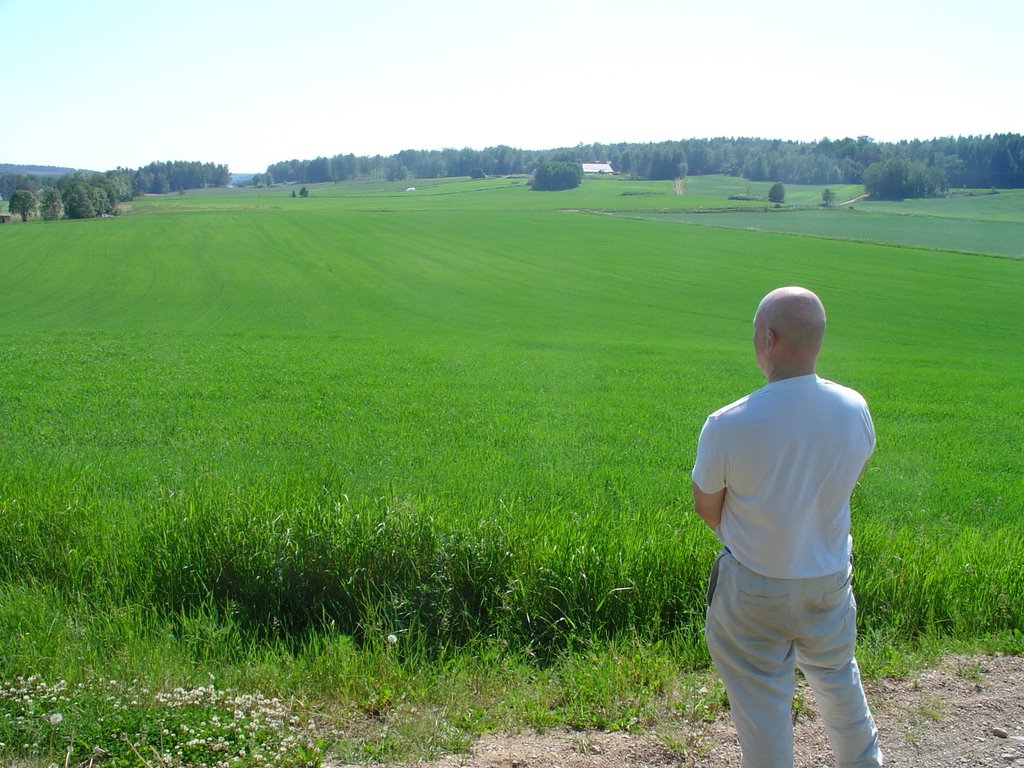
Our travels started when John and Jonas roused themselves early this morning to pick up a car for the next few days. We headed off around noon to drive back roads and document everything we laid our eyes on. Our first hour in Toija was spent driving around Lake Kirkoharvi which Vinci names as the (now flooded) plain where many of the battles of the Trojan War were fought. After touring the area we went to an open field off of the western shore of the lake to get better perspective on where the battles might have been fought. It was an amazing feeling to be finally on the very fields that represent not only the culmination of Vinci’s theory, but also the culmination of our travels. After months of planning, fundraising, and research we had finally arrived and can happily report that the moment lived up to all of our expectations.
However, our pinnacle afternoon did not stop there. Jana Shelby, our generous local host, once again came through for us and arranged to have canoes waiting at the bottom of the fields when we arrived. It was a wonderful way to get perspective on the area as a whole and also gave John an opportunity to enjoy a mid-afternoon swim.
Research Comments:
As a trained scientist, Vinci knows that the crucial requisite for a scientific hypothesis is that it be falsifiable, and indeed he references this term in the penultimate page of “Omero nel Baltico” in its 1994 Italian edition. Accordingly, he singles out for each of the two Homeric epics a primary site at which archaeological investigation could dramatically confirm or refute him: for the Iliad, the hills around Kisko in the area of Toija = Troy, and for the Odyssey, the island of Lyo = Ithaka. In the 2006 English translation he adds, at the end of this paragraph about primary candidate sites for archaeological testing of his hypothesis, that both are close to sites where actual Bronze Age structures exist.
Since our sailing began at the Greek point of departure for Troy, Nortttalje = Aulis, it was appropriate that we began our “Troy day” from the Greek point of view, at Aijala = Aigialos, Vinci’s candidate for the beach at which the Greeks landed (p. 110-112). Jana Shelby had brilliantly arranged for us to have canoes driven to us in mid-afternoon so that we could get shots of the hills on the east of lake Kirrkoharvi, the site for the citadel of Troy, and also of the plain to the west of the lake, the main battlefield between Greeks and Trojans, from a vantage on the lake itself, hence from a distance sufficient for the large topographical features to be photographed in a way that photography up close does not permit. We therefore set out in early afternoon to drive counterclockwise around the lake, starting at Aijala at its southwest end and moving slowly up to the opposite northeast end, the mile or so of ridge stretching north from the town of Kisko where Vinci suggests the citadel must have been located.
We took several photographs along this mile, at points at which we could see through the woods to the lake itself, hence experience the kind of view down onto the plain the Trojans in their citadel would have had.
In order to properly understand Vinci’s claim that this site for the citadel satisfies all the topographical descriptions of it in the Iliad (by stark contrast to Hisarlik in Turkey, pp. 104-7) it is crucial to grasp that Lake Kirrkoharvi is the result of periodic freshwater flooding from the two rivers which converge into it, Kurkelanjoki = Scamander/Xanthos from the northeast, Mammalanjoki = Simois from the northwest. Unlike many of the plains we photographed in the last few days (which would have still been inlets in the Baltic proper 4000 years, and therefore saltwater) this plain is sufficiently high to have been part of the landmass back then. It would then, as is now, have been susceptible to flooding, something Vinci points out could have formed the natural basis for the climactic scene in Iliad 21, in which Achilles provokes the wrath of the river Skamander itself by choking it with the bodies of Trojans he slays on his berserker rampage, and Skamander first berates him verbally and then actual floods the plain. We made a point of reading this entire passage out loud in Fitzgerald’s translation (pp. 494ff, 21.205-271 = 239-319 in Fitzgerald’s line numbers)
Also central to Vinci’s alignment of topographical details in the text of the Iliad with visible features near Toija is his proposal of sites for the two hills Homer mentions on the plains west of Troy, Batieia (“Thorn” or “Bramble” Hill) and Kallikolone (“Fine” or “Beautiful” Hill). The former was clearly visible to us at the north end of the lake, sticking out into it just east of where Kurkelanjoki = Skamander enters it (p. 113 and 121); Vinci himself got excellent aerial photographs of it which can be seen in the 1994 Italian edition, and we got a number too from the vantage point of the lake. We also stopped at one of a couple of islets in the northern part of the lake, and Vinci proposes that one of them might have in fact risen from the plain back then as Kallikolone (p. 121).
As moving a moment as any was our first arrival along a small dirt road at the great field west of the lake. Before following this road all the way to the lake, we took a side turn and drove up to the top of another “beautiful hill” dominating the great field from its northern end. We were able to look down on the western portion of that great field, whose eastern portion would have continued up to the Kisko ridge back then and is under the lake now. It was indeed a field level and vast enough, stretching several kilometers to the south, for us to imagine the Greeks and Trojans in huge numbers fighting on it.

posted by VTEAM06 @ 1:45 PM
0 comments
![]()

0 Comments:
Post a Comment
<< Home